Exploring Earth's Most Dangerous Zones

The planet, for all its grandeur and magnificence, is home to some extremely dangerous places where human strife, natural forces, or environmental degradation come together to create lethal situations. Some locations inspire both wonder and horror at the same time, from hostile landscapes to areas devastated by conflict. This essay sets out to investigate some of the most dangerous locations on Earth, illuminating the elements that make them dangerous as well as the consequences for humankind.
Hotspots for Natural Disasters:
1. The Ring of Fire: A Zone of Unpredictable Fury
Aptly named for its flaming geological activity, the Pacific Ring of Fire is a large region that encircles the Pacific Ocean. This horseshoe-shaped zone, which stretches over 40,000 kilometers, is home to some of the planet's most explosive and seismically active areas. The Ring of Fire, which stretches from the cold depths of Alaska to the balmy islands of Indonesia, is evidence of the planet's dynamic and frequently unexpected nature.
The network of tectonic plate borders, where the Earth's crust is constantly moving, is at the center of the Ring of Fire. These enormous plates collide and subduct, causing strong earthquakes that can occur suddenly and have catastrophic effects. Japan, which is perched on the tectonic plate of the Pacific Plate, is prone to regular earthquakes, some of which have caused enormous devastation, as was the case with the Great East Japan Earthquake of 2011.
The Ring of Fire is home to an astounding number of active volcanoes, each of which is capable of erupting torrents of molten lava and ash clouds that darken the sky, in addition to seismic activity. With more than 17,000 islands making up its archipelago, Indonesia has the highest concentration of active volcanoes worldwide. The greatest known eruption of Mount Tambora, which occurred in 1815, sent shockwaves across the world, resulting in a "year without a summer" and a severe epidemic and famine.
Nations that are located along the Ring of Fire, like Chile, Indonesia, and Japan, are always at risk from both volcanic eruptions and seismic activity. Despite significant investments in early warning systems and earthquake-resistant infrastructure, Japan—a country used to living on the brink of disaster—remains susceptible to the vagaries of nature. With its vast archipelago, Indonesia is a patchwork of various ecosystems and cultures that are all at the whim of the ferocious forces that exist beneath the surface of the earth. Chile is a country that is surrounded by the Andes Mountains and the Pacific Ocean. It has experienced some of the strongest earthquakes in recorded history.
A major concern associated with seismic activity along the Ring of Fire is the possibility of tsunamis, which are enormous waves that can severely damage coastal settlements. Over 230,000 people lost their lives and millions more were rendered homeless as a result of the 2004 Indian Ocean tsunami, which was caused by a strong underwater earthquake off the coast of Sumatra. Because of its distinct topography and tectonic activity, the Ring of Fire is especially vulnerable to producing tsunamis, which is a persistent threat to coastal towns along the Pacific Rim.
Resilience and readiness must be carefully balanced when living under the Ring of Fire's shadow. To create effective early warning systems, evacuation plans, and disaster management methods, communities, scientists, and governments must collaborate. To make sure that locals are aware of the hazards they face and know what to do in an emergency, education and awareness campaigns are essential. Nations around the Ring of Fire can lessen the effects of seismic and volcanic threats and create a future that is more resilient to nature's wrath by combining technology, innovation, and community cooperation.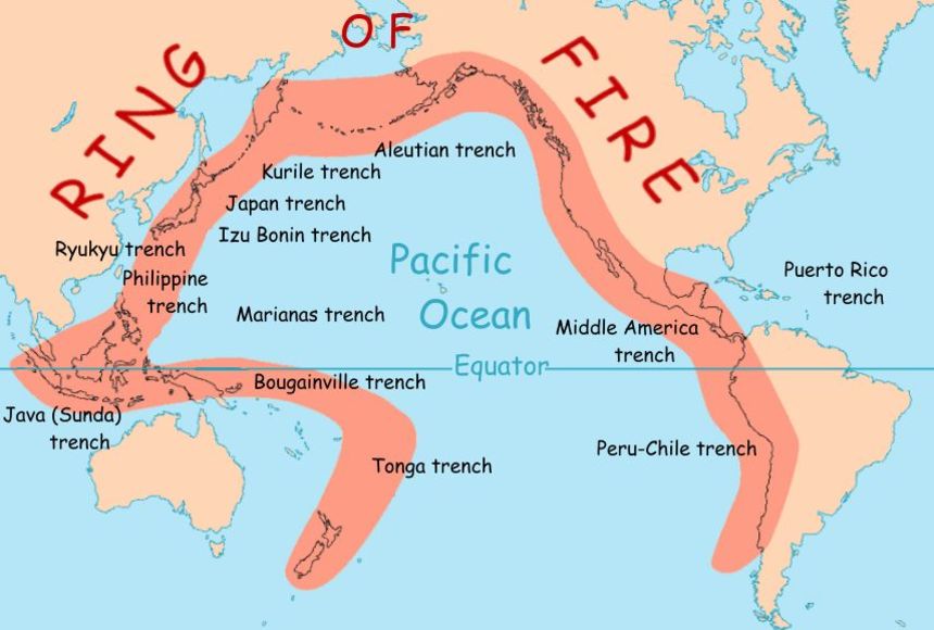
Hurricane Alley: The Front Line of Mother Nature's Wrath
Tropical cyclones, one of nature's most potent and destructive forces, find a home and breeding ground throughout Hurricane Alley, a huge corridor that runs from the coast of West Africa to the Gulf of Mexico. Warm ocean waters and ideal atmospheric conditions make this area the birthplace of multiple hurricanes annually, which is a continual threat to coastal communities in the Caribbean islands and the Southeast United States.
storm Alley's storm genesis is caused by the convergence of warm, humid air over the Atlantic Ocean's tropical waters. A tropical disturbance is a swirling mass of clouds and thunderstorms created when this air rises and cools and condenses to form massive thunderstorms. The heat and moisture of the ocean below can cause these disturbances to organize and intensify under the correct circumstances, eventually developing into tropical depressions, tropical storms, and hurricanes.
Hurricanes in Hurricane Alley have the potential to cause immense damage once they develop. The Caribbean islands are most affected by these strong hurricanes since they are directly in their path. No region of the Caribbean is safe from a hurricane's fury, from Puerto Rico's lush jungles to Barbados' windswept beaches. States like Florida, Georgia, and the Carolinas are among those in the southeastern United States that are most vulnerable to severe storms, as they face the combined threat of violent winds and storm surges.
Hurricanes in Hurricane Alley have the potential to be extremely destructive, wreaking havoc on homes, businesses, and other infrastructure. Strong winds have the ability to uproot trees, rip off building roofs, and launch debris skyward like bullets. Excessive precipitation can cause landslides and flash floods, submerging low-lying areas and destroying bridges and roadways. Storm surges can engulf coastal cities in walls of water, causing significant damage and fatalities as a result of the hurricane's winds and low air pressure.
Affected populations must pick up the pieces and reconstruct their lives from the wreckage following a hurricane. Residents are left reeling from the magnitude of their losses while emergency personnel race to offer support and aid. Years may pass between rebuilding projects, which need for large investments in housing, infrastructure, and catastrophe preparedness. Future planning takes into account the lessons acquired from previous hurricanes, emphasizing resilience and adaptation in the face of climate change.
Floodplains and River Deltas: Coastal Warfare Zones
The lush, productive areas known as river deltas, which are created at the mouths of large rivers, are frequently hive centers of activity that are brimming with people and business. Millions of people live in these densely populated areas, but they are also extremely vulnerable to catastrophic flooding, which poses a continual threat. This vulnerability is never more evident than in Bangladesh's Ganges-Brahmaputra Delta, where a number of interrelated circumstances have transformed ordinary floods into a persistent humanitarian calamity.
The largest delta in the world, spanning the boundary between Bangladesh and India, is the Ganges-Brahmaputra Delta, with a surface area of more than 100,000 square kilometers. This huge, lush region, which is nourished by the powerful Ganges and Brahmaputra rivers, is home to more than 160 million people, making it one of the most densely populated areas on Earth. Life in the delta is centered around the rhythms of the rivers, from thriving metropolises like Dhaka to little rural communities tucked away among the rice paddies.
A cycle of severe floods that occur with frightening frequency plagues the Ganges-Brahmaputra Delta despite its fertile farmland and plentiful water resources. Large-scale flooding occurs when rivers in the Indian subcontinent and the Himalayas overrun their banks due to high rainfall during the monsoon season, covering large areas of land. Floods that follow can leave populations vulnerable and stuck by submerging homes, destroying crops, and upsetting essential infrastructure.
The Ganges-Brahmaputra Delta is more likely to flood due to a number of variables, which exacerbates the effects of natural disasters on nearby towns. Increased runoff and soil erosion result from upstream regions' forests' diminished ability to absorb rainfall and control river flow. The natural drainage of floodwaters is further restricted by encroaching urbanization and land reclamation projects onto natural floodplains and wetlands. Floods in the delta are becoming more intense and frequent due to climate change, which is also causing sea levels to rise and more extreme weather.
Flooding in the Ganges-Brahmaputra Delta presents a number of difficulties that call for a multifaceted strategy that integrates climate adaptation, sustainable development, and catastrophe preparedness. By acting as organic barriers against erosion and storm surges, restored and preserved natural ecosystems—such as wetlands and mangrove forests—can lessen the effects of flooding. Early warning systems, infrastructure improvements, and community-based disaster management programs can all help make local areas more resilient to floods in the future.
The Ganges-Brahmaputra Delta's predicament serves as a sobering reminder of the intricate relationship between environmental risks and human vulnerability. Drastic action is required to increase resilience and prepare for the challenges of a changing environment as climate change continues to intensify the frequency and intensity of floods in sensitive areas like the delta. For the millions of people who live in flood-prone areas worldwide, we can contribute to a safer and more secure future by making investments in sustainable development, disaster preparedness, and community empowerment.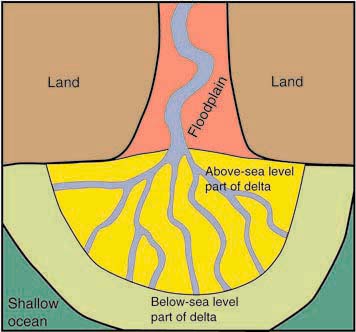
Extreme Conditions:
The Sahara Desert, which stretches across North Africa, is proof of the beauty and ferocity of nature. The Sahara, which covers a region larger than the entire United States, is not only the world's largest hot desert but also one of the most difficult places for humans to survive. For those who go across its parched expanse, the Sahara poses great challenges due to its extreme heat, wide stretches of sand dunes, and scarce water supplies.
The scenery of the Sahara is distinguished by its harsh circumstances and striking contrasts. Nighttime lows can approach freezing, but daytime highs can climb to scorching heights of far over 50 degrees Celsius (122 degrees Fahrenheit). There is little to no annual precipitation in many places, with others receiving less than 25 millimeters. Sand dunes, stony plateaus, and untamed mountains dominate the landscape, with sporadic oasis and dry riverbeds scattered throughout.
There is life in the Sahara despite its harsh environment. For millennia, nomadic groups like the Tuareg and Bedouin have lived in the desert, where they have honed their skills in adaptability and perseverance to survive. These people who live in the desert have evolved special ways of surviving the hard environment. These include survival skills and sophisticated understanding of desert navigation, in addition to conventional methods of conserving water.
The Sahara's most valuable resource is water, and the desert's way of life is determined by its scarcity. Nomadic tribes frequently travel great distances in search of water, relying on a network of wells, springs, and subterranean aquifers to support themselves and their animals. In an otherwise desolate environment, the production of drought-resistant crops, including millet and dates, offers a crucial source of nutrition. Conventional techniques for conserving water, such building qanats (subterranean tunnels) and fog nets, help make the most of the few water supplies.
The Sahara is home to an unexpected diversity of plant and animal life, each specially suited to thrive in this harsh environment, despite its severe surroundings. In order to survive the harsh climate and lack of resources, endemic animals have evolved specific physiological and behavioral adaptations, such as the Barbary sheep, addax antelope, and dromedary camel. Acacia trees, date palms, and other succulent plants are examples of desert-adapted flora that flourish in the sandy soils and dry temperature of the region. These plants are essential for maintaining dunes and provide a haven for wildlife. The Sahara offers great obstacles to human life, but it also has a wealth of opportunities for sustainable development, cultural exploration, and scientific research. Technological innovations like desalination and solar energy present viable ways to use the desert's plentiful sunshine to turn saltwater into freshwater. Initiatives for ecotourism that highlight the distinctive landscapes and indigenous cultures of the Sahara offer chances for both cultural and economic exchange. Through the adoption of creativity, preservation, and cooperation, we can uncover the Sahara's undiscovered riches and guarantee a more promising future for the inhabitants and ecosystems of this exceptional wild area. 
Antarctica: The Exploration Frontier Freeze-Dried
The southernmost continent, Antarctica, is a pristine and dangerous wilderness that fascinates scientists and explorers alike. Antarctica is known for being among the most hostile areas on Earth, where survival is a never-ending struggle against the harsh environment, despite its spectacular beauty. For those who dare to journey into its icy grasp, this frozen continent provides exceptional obstacles, including bone-chilling cold, powerful winds, and isolation.
Bone-chilling temperatures—which can drop as low as -80 degrees Celsius (-112 degrees Fahrenheit) during the winter—are a defining feature of Antarctica's harsh environment. In addition, the continent is frequently battered by katabatic winds, which can reach speeds greater than hurricane force and produce blizzard conditions that impair vision and make travel dangerous. The isolation of Antarctica, where access is restricted to a small number of research stations and expedition bases dispersed along the coast, presents additional difficulties on top of the cold and wind.
There is life in Antarctica despite its harsh environment. Along the ice coastlines, penguins, seals, and seagulls flourish, while beneath the freezing waters, krill and other marine life support a rich and varied ecology. The majority of human habitation in Antarctica is restricted to scientific research stations run by different nations, where groups of scientists and support personnel brave long months of darkness and isolation in order to carry out ground-breaking research in disciplines like marine biology, glaciology, and climate science.
Careful planning, preparation, and fortitude in the face of the harshest elements of nature are necessary for survival in Antarctica. Polar-grade sleeping bags, high-tech tents, and insulated outerwear are just a few of the specialist equipment and clothes used on Antarctic expeditions that are made to survive intense cold and wind. When resupply operations are not feasible during the winter, food supplies must be properly rationed and stored to guarantee an adequate supply. In order to lessen the likelihood of mishaps and incidents in this harsh and isolated location, communication networks, medical facilities, and emergency procedures are in place.
Because of its untamed beauty and pristine landscapes, Antarctica has always captivated the attention of explorers, adventurers, and scientists despite the hardships of survival. Antarctica continues to inspire awe and amazement as a crucible of discovery and invention, from the glorious period of Antarctic exploration led by heroes like Ernest Shackleton and Robert Falcon Scott to contemporary expeditions supported by cutting-edge technology and international collaboration. Antarctic scientific research has provided priceless insights into the planet's climate system, glacier dynamics, and biodiversity. These discoveries have helped to solve global environmental concerns and solve some of the planet's mysteries.
Conservation and management are now crucial because of the mounting strain that climate change and human activity are placing on Antarctica's delicate ecosystems. International accords that establish Antarctica as a continent devoted to science and peace, like the Antarctic Treaty System, offer a foundation for collaboration and environmental preservation. For the sake of future generations, Antarctica's pristine wilderness must be preserved by efforts to lessen human impacts, such as restricting tourism and controlling fishing.
Antarctica is a living example of how resilient life is and how persistent the spirit of discovery can be. Antarctica draws scientists and explorers to explore its mysteries and discover its secrets despite its hostile environment and remote location. For future generations, Antarctica may serve as a source of inspiration and exploration if we embrace innovation, teamwork, and protection.
The Deep Sea: The Mysterious Abyss
Beneath the world's oceans' glittering surface is a place of unmatched mystery and fascination called the deep sea. The deep sea is one of the most mysterious and least explored areas of the planet because of its intense temperatures, crushing pressures, and constant darkness. Submarine trenches, like the Mariana Trench, serve as eerie reminders of the great depths and difficult obstacles that lie ahead for anybody brave enough to enter this terrifying world.
The huge areas of water below 200 meters (656 feet), when sunlight fades into darkness and pressure reaches incredible heights, are collectively referred to as the deep sea. The weight of the water above creates crushing forces that can reach 1,000 times the atmospheric pressure at sea level at depths greater than 1,000 meters (3,280 feet). In order to exist in this harsh environment, both humans and marine life must adapt to these extreme conditions, which present serious challenges to both.
The deep water is always dark when sunlight isn't present, resulting in a surreal environment that is only sometimes lit by the glow of hydrothermal vents and bioluminescent creatures. Deep-sea animals have evolved numerous adaptations to withstand darkness. For example, many species have huge eyes or light-producing organs to help them navigate and communicate in the poorly lighted depths. Artificial light sources and cutting-edge imaging technologies are crucial for humans venturing into the deep sea and uncovering its secrets.
Temperatures in the deep water vary greatly; near the surface, they are almost freezing, while near hydrothermal vents and cold seeps, they are almost boiling. Hydrothermal vents—cracks in the ocean floor where superheated water erupts from the Earth's mantle—create sanctuaries of warmth and energy that support distinct ecosystems teeming with life despite the freezing cold of the deep ocean. The ability of deep-sea animals and the scientists who study them to survive is put to the test by these enormous temperature variations.
The Mariana Trench in the western Pacific Ocean is the deepest known location on Earth's surface, reaching a depth of approximately 10,000 meters (almost 7 miles). This undersea trench, named for the adjacent Mariana Islands, descends to unfathomably low depths where temperatures are just above freezing and pressures surpass 1,000 times that of atmospheric pressure. The Mariana Trench is home to a wide variety of life despite its harsh environment, such as deep-sea fish, enormous amphipods, and microbial communities that flourish in the abyss's darkness.
Deep water exploration has substantial logistical, biological, and technical problems that call for creative thinking and interdisciplinary cooperation. Scientists can now explore the deep sea in unprecedented depth thanks to submarines, remotely operated vehicles (ROVs), and autonomous underwater vehicles (AUVs) outfitted with cutting-edge sensors and imaging systems that reveal hidden ecosystems, geological features, and biological processes. Research expeditions to the deep sea, like those carried out by the Schmidt Ocean Institute and the National Oceanic and Atmospheric Administration (NOAA), push the frontiers of science and deepen our knowledge of the deep sea's influence on the climate, biodiversity, and geology of the planet.
The delicate deep-sea ecosystems are threatened by human activities like bottom trawling and deep-sea mining, therefore conservation efforts are crucial to safeguarding this delicate environment. A framework for the sustainable management of deep-sea resources and the preservation of biodiversity is provided by international agreements like the International Seabed Authority (ISA) and the United Nations Convention on the Law of the Sea (UNCLOS). Marine reserves and protected areas (MPAs) are essential for preventing the negative effects of human exploitation on delicate ecosystems and species. The frontiers of human knowledge are continuously being pushed and expanded in the deep sea, which is still a place of mystery and wonder. We can discover the mysteries of the deep sea and make sure that this unique ecosystem continues to captivate and inspire future generations by embracing exploration, conservation, and sustainable management.
Environmental Deterioration:
The Exclusion Zone Around Chernobyl: A Sordid Reminder of Nuclear Disaster:
The location of the worst nuclear accident in recorded history, the Chernobyl Exclusion Zone, serves as a somber reminder of the devastating effects of nuclear catastrophes. The Exclusion Zone at the Chernobyl Nuclear Power Plant is still a barren, very radioactive area that is uninhabitable for both people and wildlife decades after the plant melted down. The disaster's long-term health repercussions are nevertheless a sobering reminder of the permanent damage that nuclear accidents can do to populations in the vicinity.
A sequence of disastrous incidents transpired at the Chernobyl Nuclear Power Plant in the present-day northern Ukraine on April 26, 1986. A large explosion and subsequent meltdown caused by a defective reactor design, human error, and inadequate safety standards released a plume of radioactive material into the atmosphere. Confusing events, a rush to contain radioactive pollution spreading across Europe, and secrecy typified the immediate aftermath of the tragedy. Following the accident, a sizable portion of the territory around the Chernobyl Nuclear Power Plant was named the Exclusion Zone, an area with high radiation levels that is carefully regulated for entry. Over 2,600 square kilometers of rivers, forests, and deserted villages are included in the Exclusion Zone; they are all trapped in time by the radiation's unseen shadow. Once the residence of thousands of laborers and their families, the city of Pripyat serves as a spectral reminder of the human tragedy that followed the meltdown. Even now, the Chernobyl Exclusion Zone is very radioactive, putting anyone who enters its borders at serious risk to their health. Even though radiation levels have dropped over time as a result of remediation activities and radioactive decay, some portions of the Exclusion Zone are still inaccessible to anyone other than the most highly skilled and prepared workers. Nearby communities are still impacted by the long-term health effects of ionizing radiation exposure, especially those who are actively participating in the cleanup and recovery activities. These effects include an increased risk of cancer, genetic abnormalities, and reproductive issues. The effects of the Chernobyl accident on the environment are felt far beyond the walls of the Exclusion Zone, as radioactive pollution may still be found in soil, water, and animals in large parts of Russia, Belarus, and Ukraine. The discharge of radioactive isotopes has permanently changed forests, rivers, and ecosystems, causing mutations, a loss of biodiversity, and disturbances to biological processes. Even with all of the measures made to lessen the disaster's environmental repercussions, research into the long-term effects of radiation on the natural world is still underway. The catastrophic Chernobyl accident serves as a sobering reminder of the dangers that come with nuclear energy and the necessity of strict safety laws and inspections. The human cost of nuclear accidents—the lives lost and the communities uprooted—highlights the necessity of openness, responsibility, and international collaboration in the operation of nuclear facilities and emergency response. The lessons from Chernobyl must guide policy development and decision-making as the world struggles to transition to a low-carbon energy future in order to prevent the mistakes of the past from happening again.
The Amazon Rainforest: A Valuable Ecosystem under Danger
The Amazon rainforest, sometimes called the "lungs of the Earth," is the world's biggest tropical rainforest, encompassing nine South American countries and more than 6.7 million square kilometers. But because to deforestation, wildfires, and human activity, this magnificent and biodiverse ecosystem is facing enormous threats that threaten not only its rich biodiversity but also the world climate and the livelihoods of millions of people who live there. Deforestation in the Amazon rainforest has increased alarmingly in recent years, mostly due to illegal logging, increased agricultural production, and infrastructure construction. Every year, enormous tracts of virgin forest are destroyed to make room for industrial mining, soy farming, and cattle ranching, which causes an irrevocable loss of biodiversity and habitat. Furthermore, the frequency and intensity of wildfires in the area have increased due to climate change, which has further contributed to carbon emissions and the deterioration of the forest.
A staggering variety of plant and animal species, many of which are unique to Earth, can be found in the Amazon jungle. The Amazon is home to an unmatched diversity of life, including hundreds of species that science has not yet identified or documented. These species include jaguars, tapirs, toucans, and tree frogs. The survival of indigenous populations that depend on the forest for their way of life as well as the delicate balance of ecosystems are in jeopardy due to widespread deforestation and habitat devastation, which is driving many species towards extinction. Because of the demand for wood and other forest products, illegal logging is a major danger to the Amazon rainforest's integrity. In order to steal rare and expensive hardwoods, criminal networks take advantage of corruption and lax law enforcement, which depletes forest resources and undermines attempts at sustainable management. Protected areas and indigenous territories are being further destroyed by land grabbing, which is made worse by government policies that favor economic development over environmental preservation and frequently involves fake land titles. The future of the Amazon rainforest is largely determined by government policy and environmental stewardship. While some nations have achieved significant progress in safeguarding and conserving their forest resources, others have placed a higher priority on immediate financial gain than long-term sustainability, which has resulted in a lax enforcement of environmental laws and a general lack of consequences for illicit activity. There have been calls for more stringent measures to stop deforestation and make companies and governments responsible for their acts due to public uproar and international pressure.
Because it releases oxygen into the atmosphere through photosynthesis and absorbs carbon dioxide, the Amazon rainforest is essential to controlling the planet's temperature. Large volumes of carbon held in soil and plants are released into the atmosphere by wildfires and deforestation, which exacerbates climate change and global warming. The stability of the planet's climate system is seriously threatened by the disappearance of the Amazon's carbon sink, which not only quickens the rate of climate change but also undercuts attempts to lessen its effects. With deforestation, wildfires, and human exploitation posing previously unheard-of risks, the Amazon rainforest is at a crossroads. To stop the devastation of this essential ecosystem and safeguard the biodiversity, native cultures, and international climate systems that depend on it, immediate action is required. The Amazon rainforest and all those who depend on it may have a better and more sustainable future if we address the underlying causes of deforestation, bolster environmental governance, and encourage sustainable development.
Hotspots for Pollution: Fighting the Invisible Danger
Pollution hotspots serve as a sobering reminder of the environmental costs of human progress, both in the shadow of industrial hubs and amidst the concrete jungles of urban centers. These regions bear the brunt of unchecked pollution, from the toxic rivers that snake through developing nations to the dense smog that chokes cities like Delhi. As a result, millions of people in these areas face serious health risks, underscoring the urgent need for environmental regulation and sustainable development. Urbanization, industrialization, and population increase have resulted in rapid air and water pollution, which is a problem that cities worldwide are facing. Toxic pollution obscures the sky in megacities like Delhi, Beijing, and São Paulo, increasing the incidence of respiratory ailments like lung cancer and asthma and posing serious health hazards. A poisonous concoction of pollutants permeates the air due to increased amounts of particulate matter, nitrogen oxides, and volatile organic compounds caused by industrial emissions, vehicle pollution, and open burning of garbage.
Pollution is concentrated in industrial hubs where firms release hazardous waste streams and poisonous fumes into the surrounding air. These regions, which range from the coal mines of China's Shanxi province to the petrochemical factories along the US Gulf Coast, are distinguished by low air quality, tainted water supplies, and high prevalence of illnesses linked to pollution among the workforce and the local populace. Lead, mercury, and cadmium are examples of heavy metals that can contaminate soil and water and endanger ecological integrity as well as human health. In many parts of the world, especially in developing nations where rules pertaining to industrial discharge and insufficient wastewater treatment lead to the contamination of rivers, lakes, and groundwater sources, water pollution is an urgent concern. These water bodies, which are vital to millions of people but also pose serious hazards to their health and well-being, range from the Citarum River in Indonesia to the Ganges River in India, which is contaminated by plastic trash and raw sewage. Pollution hotspots have significant negative effects on public health that are widespread and disproportionately affect vulnerable groups such as children, the elderly, and low-income areas. The risk of respiratory illnesses, cardiovascular problems, neurological impairments, and several types of cancer is increased when one is exposed to air and water pollution. The majority of underprivileged groups that live near industrial facilities and pollution sources bear the brunt of pollution-related illnesses, which exacerbates already-existing health inequities and feeds the cycle of poverty and illness. Pollution hotspots must be addressed with a multimodal strategy that includes investments in clean technologies and sustainable development along with strict environmental control. To hold polluters responsible for their acts, governments need to bolster monitoring and enforcement tools and implement already-existing environmental regulations.