EARTH 2
Physical characteristics
Further information: Geophysics
Size and shape
Main article: Figure of the Earth
Further information: Earth radius, Earth's circumference, Earth curvature, and Geomorphology
See also: List of highest mountains on Earth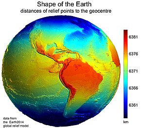 Earth's western hemisphere showing topography relative to Earth's center instead of to mean sea level, as in common topographic maps
Earth has a rounded shape, through hydrostatic equilibrium,[84] with an average diameter of 12,742 kilometers (7,918 mi), making it the fifth largest planetary sized and largest terrestrial object of the Solar System.[85]
Due to Earth's rotation it has the shape of an ellipsoid, bulging at its Equator; its diameter is 43 kilometers (27 mi) longer there than at its poles.[86][87] Earth's shape furthermore has local topographic variations. Though the largest local variations, like the Mariana Trench (10,925 meters or 35,843 feet below local sea level),[88] only shortens Earth's average radius by 0.17% and Mount Everest (8,848 meters or 29,029 feet above local sea level) lengthens it by only 0.14%.[n 5][90] Since Earth's surface is farthest out from Earth's center of mass at its equatorial bulge, the summit of the volcano Chimborazo in Ecuador (6,384.4 km or 3,967.1 mi) is its farthest point out.[91][92] Parallel to the rigid land topography the Ocean exhibits a more dynamic topography.[93]
To measure the local variation of Earth's topography, geodesy employs an idealized Earth producing a shape called a geoid. Such a geoid shape is gained if the ocean is idealized, covering Earth completely and without any perturbations such as tides and winds. The result is a smooth but gravitational irregular geoid surface, providing a mean sea level (MSL) as a reference level for topographic measurements.[94]
Surface
Further information: Planetary surface, Land cover, Land, Pedosphere, Ocean, Sea, Cryosphere, and Peplosphere A composite image of Earth, with its different types of surface discernible: Earth's surface dominating Ocean (blue), Africa with lush (green) to dry (brown) land and Earth's polar ice in the form of Antarctic sea ice (grey) covering the Antarctic or Southern Ocean and the Antarctic ice sheet (white) covering Antarctica.
 Relief of Earth's crust
Earth's surface is the boundary between the atmosphere, and the solid Earth and oceans. Defined in this way, Earth's shape is an idealized spheroid – a squashed sphere – with a surface area of about 510 million km2 (197 million sq mi).[12] Earth can be divided into two hemispheres: by latitude into the polar Northern and Southern hemispheres; or by longitude into the continental Eastern and Western hemispheres.
Most of Earth's surface is ocean water: 70.8% or 361 million km2 (139 million sq mi).[95] This vast pool of salty water is often called the world ocean,[96][97] and makes Earth with its dynamic hydrosphere a water world[98][99] or ocean world.[100][101] Indeed, in Earth's early history the ocean may have covered Earth completely.[102] The world ocean is commonly divided into the Pacific Ocean, Atlantic Ocean, Indian Ocean, Antarctic or Southern Ocean, and Arctic Ocean, from largest to smallest. The ocean covers Earth's oceanic crust, but to a lesser extent with shelf seas also shelves of the continental crust. The oceanic crust forms large oceanic basins with features like abyssal plains, seamounts, submarine volcanoes,[86] oceanic trenches, submarine canyons, oceanic plateaus, and a globe-spanning mid-ocean ridge system.
At Earth's polar regions, the ocean surface is covered by seasonally variable amounts of sea ice that often connects with polar land, permafrost and ice sheets, forming polar ice caps.
Earth's land covers 29.2%, or 149 million km2 (58 million sq mi) of Earth's surface. The land surface includes many islands around the globe, but most of the land surface is taken by the four continental landmasses, which are (in descending order): Africa-Eurasia, America (landmass), Antarctica, and Australia (landmass).[103][104][105] These landmasses are further broken down and grouped into the continents. The terrain of the land surface varies greatly and consists of mountains, deserts, plains, plateaus, and other landforms. The elevation of the land surface varies from a low point of −418 m (−1,371 ft) at the Dead Sea, to a maximum altitude of 8,848 m (29,029 ft) at the top of Mount Everest. The mean height of land above sea level is about 797 m (2,615 ft).[106]
Land can be covered by surface water, snow, ice, artificial structures or vegetation. Most of Earth's land hosts vegetation,[107] but ice sheets (10%,[108] not including the equally large land under permafrost)[109] or cold as well as hot deserts (33%)[110] occupy also considerable amounts of it.
The pedosphere is the outermost layer of Earth's land surface and is composed of soil and subject to soil formation processes. Soil is crucial for land to be arable. Earth's total arable land is 10.7% of the land surface, with 1.3% being permanent cropland.[111][112] Earth has an estimated 16.7 million km2 (6.4 million sq mi) of cropland and 33.5 million km2 (12.9 million sq mi) of pastureland.[113]
The land surface and the ocean floor form the top of Earth's crust, which together with parts of the upper mantle form Earth's lithosphere. Earth's crust may be divided into oceanic and continental crust. Beneath the ocean-floor sediments, the oceanic crust is predominantly basaltic, while the continental crust may include lower density materials such as granite, sediments and metamorphic rocks.[114] Nearly 75% of the continental surfaces are covered by sedimentary rocks, although they form about 5% of the mass of the crust.[115]
Earth's surface topography comprises both the topography of the ocean surface, and the shape of Earth's land surface. The submarine terrain of the ocean floor has an average bathymetric depth of 4 km, and is as varied as the terrain above sea level.
Earth's surface is continually being shaped by internal plate tectonic processes including earthquakes and volcanism; by weathering and erosion driven by ice, water, wind and temperature; and by biological processes including the growth and decomposition of biomass into soil.[116][117]
Tectonic plates
Main article: Plate tectonics Earth's major plates, which are:[118]
- Pacific Plate African Plate[n 6] North American Plate Eurasian Plate Antarctic Plate Indo-Australian Plate South American Plate
Earth's mechanically rigid outer layer of Earth's crust and upper mantle, the lithosphere, is divided into tectonic plates. These plates are rigid segments that move relative to each other at one of three boundaries types: at convergent boundaries, two plates come together; at divergent boundaries, two plates are pulled apart; and at transform boundaries, two plates slide past one another laterally. Along these plate boundaries, earthquakes, volcanic activity, mountain-building, and oceanic trench formation can occur.[119] The tectonic plates ride on top of the asthenosphere, the solid but less-viscous part of the upper mantle that can flow and move along with the plates.[120]
As the tectonic plates migrate, oceanic crust is subducted under the leading edges of the plates at convergent boundaries. At the same time, the upwelling of mantle material at divergent boundaries creates mid-ocean ridges. The combination of these processes recycles the oceanic crust back into the mantle. Due to this recycling, most of the ocean floor is less than 100 Ma old. The oldest oceanic crust is located in the Western Pacific and is estimated to be 200 Ma old.[121][122] By comparison, the oldest dated continental crust is 4,030 Ma,[123] although zircons have been found preserved as clasts within Eoarchean sedimentary rocks that give ages up to 4,400 Ma, indicating that at least some continental crust existed at that time.[50]
The seven major plates are the Pacific, North American, Eurasian, African, Antarctic, Indo-Australian, and South American. Other notable plates include the Arabian Plate, the Caribbean Plate, the Nazca Plate off the west coast of South America and the Scotia Plate in the southern Atlantic Ocean. The Australian Plate fused with the Indian Plate between 50 and 55 Ma. The fastest-moving plates are the oceanic plates, with the Cocos Plate advancing at a rate of 75 mm/a (3.0 in/year)[124] and the Pacific Plate moving 52–69 mm/a (2.0–2.7 in/year). At the other extreme, the slowest-moving plate is the South American Plate, progressing at a typical rate of 10.6 mm/a (0.42 in/year).[125]
Internal structure
Main article: Internal structure of Earth
Geologic layers of Earth[126]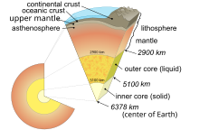 Illustration of Earth's cutaway, not to scaleDepth[127]
(km)Component
layer nameDensity
(g/cm3)0–60Lithosphere[n 7]—0–35Crust[n 8]2.2–2.935–660Upper mantle3.4–4.4660–2890Lower mantle3.4–5.6100–700Asthenosphere—2890–5100Outer core9.9–12.25100–6378Inner core12.8–13.1
Earth's interior, like that of the other terrestrial planets, is divided into layers by their chemical or physical (rheological) properties. The outer layer is a chemically distinct silicate solid crust, which is underlain by a highly viscous solid mantle. The crust is separated from the mantle by the Mohorovičić discontinuity.[128] The thickness of the crust varies from about 6 kilometers (3.7 mi) under the oceans to 30–50 km (19–31 mi) for the continents. The crust and the cold, rigid, top of the upper mantle are collectively known as the lithosphere, which is divided into independently moving tectonic plates.[129]
Beneath the lithosphere is the asthenosphere, a relatively low-viscosity layer on which the lithosphere rides. Important changes in crystal structure within the mantle occur at 410 and 660 km (250 and 410 mi) below the surface, spanning a transition zone that separates the upper and lower mantle. Beneath the mantle, an extremely low viscosity liquid outer core lies above a solid inner core.[130] Earth's inner core may be rotating at a slightly higher angular velocity than the remainder of the planet, advancing by 0.1–0.5° per year, although both somewhat higher and much lower rates have also been proposed.[131] The radius of the inner core is about one-fifth of that of Earth. Density increases with depth, as described in the table on the right.
Among the Solar System's planetary-sized objects Earth is the object with the highest density.
Chemical composition
See also: Abundance of elements on Earth
Earth's mass is approximately 5.97×1024 kg (5,970 Yg). It is composed mostly of iron (32.1% by mass), oxygen (30.1%), silicon (15.1%), magnesium (13.9%), sulfur (2.9%), nickel (1.8%), calcium (1.5%), and aluminum (1.4%), with the remaining 1.2% consisting of trace amounts of other elements. Due to gravitational separation, the core is primarily composed of the denser elements: iron (88.8%), with smaller amounts of nickel (5.8%), sulfur (4.5%), and less than 1% trace elements.[132][49] The most common rock constituents of the crust are oxides. Over 99% of the crust is composed of various oxides of eleven elements, principally oxides containing silicon (the silicate minerals), aluminum, iron, calcium, magnesium, potassium, or sodium.[133][132]
Internal heat
Main article: Earth's internal heat budget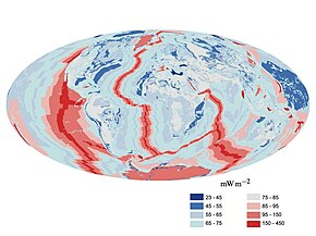 A map of heat flow from Earth's interior to the surface of Earth's crust, mostly along the oceanic ridges
The major heat-producing isotopes within Earth are potassium-40, uranium-238, and thorium-232.[134] At the center, the temperature may be up to 6,000 °C (10,830 °F),[135] and the pressure could reach 360 GPa (52 million psi).[136] Because much of the heat is provided by radioactive decay, scientists postulate that early in Earth's history, before isotopes with short half-lives were depleted, Earth's heat production was much higher. At approximately 3 Gyr, twice the present-day heat would have been produced, increasing the rates of mantle convection and plate tectonics, and allowing the production of uncommon igneous rocks such as komatiites that are rarely formed today.[137][138]
The mean heat loss from Earth is 87 mW m−2, for a global heat loss of 4.42×10¹³ W.[139] A portion of the core's thermal energy is transported toward the crust by mantle plumes, a form of convection consisting of upwellings of higher-temperature rock. These plumes can produce hotspots and flood basalts.[140] More of the heat in Earth is lost through plate tectonics, by mantle upwelling associated with mid-ocean ridges. The final major mode of heat loss is through conduction through the lithosphere, the majority of which occurs under the oceans because the crust there is much thinner than that of the continents.[141]
Gravitational field
Main article: Gravity of Earth
The gravity of Earth is the acceleration that is imparted to objects due to the distribution of mass within Earth. Near Earth's surface, gravitational acceleration is approximately 9.8 m/s2 (32 ft/s2). Local differences in topography, geology, and deeper tectonic structure cause local and broad regional differences in Earth's gravitational field, known as gravity anomalies.[142]
Magnetic field
Main article: Earth's magnetic field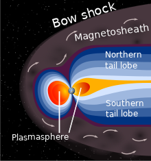 A schematic view of Earth's magnetosphere with solar wind flowing from left to right
The main part of Earth's magnetic field is generated in the core, the site of a dynamo process that converts the kinetic energy of thermally and compositionally driven convection into electrical and magnetic field energy. The field extends outwards from the core, through the mantle, and up to Earth's surface, where it is, approximately, a dipole. The poles of the dipole are located close to Earth's geographic poles. At the equator of the magnetic field, the magnetic-field strength at the surface is 3.05×10⁻⁵ T, with a magnetic dipole moment of 7.79×10²² Am2 at epoch 2000, decreasing nearly 6% per century (although it still remains stronger than its long time average).[143] The convection movements in the core are chaotic; the magnetic poles drift and periodically change alignment. This causes secular variation of the main field and field reversals at irregular intervals averaging a few times every million years. The most recent reversal occurred approximately 700,000 years ago.[144][145]
The extent of Earth's magnetic field in space defines the magnetosphere. Ions and electrons of the solar wind are deflected by the magnetosphere; solar wind pressure compresses the dayside of the magnetosphere, to about 10 Earth radii, and extends the nightside magnetosphere into a long tail.[146] Because the velocity of the solar wind is greater than the speed at which waves propagate through the solar wind, a supersonic bow shock precedes the dayside magnetosphere within the solar wind.[147] Charged particles are contained within the magnetosphere; the plasmasphere is defined by low-energy particles that essentially follow magnetic field lines as Earth rotates.[148][149] The ring current is defined by medium-energy particles that drift relative to the geomagnetic field, but with paths that are still dominated by the magnetic field,[150] and the Van Allen radiation belts are formed by high-energy particles whose motion is essentially random, but contained in the magnetosphere.[151][152]
During magnetic storms and substorms, charged particles can be deflected from the outer magnetosphere and especially the magnetotail, directed along field lines into Earth's ionosphere, where atmospheric atoms can be excited and ionized, causing the aurora.[153]
Orbit and rotation
Rotation
Main article: Earth's rotation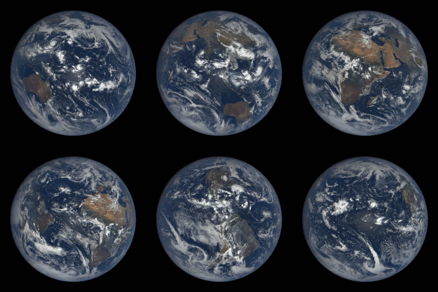 Satellite time lapse imagery of Earth's rotation showing axis tilt
Earth's rotation period relative to the Sun—its mean solar day—is 86,400 seconds of mean solar time (86,400.0025 SI seconds).[154] Because Earth's solar day is now slightly longer than it was during the 19th century due to tidal deceleration, each day varies between 0 and 2 ms longer than the mean solar day.[155][156]
Earth's rotation period relative to the fixed stars, called its stellar day by the International Earth Rotation and Reference Systems Service (IERS), is 86,164.0989 seconds of mean solar time (UT1), or 23h 56m 4.0989s.[2][n 9] Earth's rotation period relative to the precessing or moving mean March equinox (when the Sun is at 90° on the equator), is 86,164.0905 seconds of mean solar time (UT1) (23h 56m 4.0905s).[2] Thus the sidereal day is shorter than the stellar day by about 8.4 ms.[157]
Apart from meteors within the atmosphere and low-orbiting satellites, the main apparent motion of celestial bodies in Earth's sky is to the west at a rate of 15°/h = 15'/min. For bodies near the celestial equator, this is equivalent to an apparent diameter of the Sun or the Moon every two minutes; from Earth's surface, the apparent sizes of the Sun and the Moon are approximately the same.[158][159]
Orbit
Main articles: Earth's orbit and Earth's location Exaggerated illustration of Earth's elliptical orbit around the Sun, marking that the orbital extreme points (apoapsis and periapsis) are not the same as the four seasonal extreme points, the equinox and solstice
Earth orbits the Sun, making Earth the third-closest planet to the Sun and part of the inner Solar System. Earth's average orbital distance is about 150 million km (93 million mi), which is the basis for the Astronomical Unit and is equal to roughly 8.3 light minutes or 380 times Earth's distance to the Moon.
Earth orbits the Sun every 365.2564 mean solar days, or one sidereal year. With an apparent movement of the Sun in Earth's sky at a rate of about 1°/day eastward, which is one apparent Sun or Moon diameter every 12 hours. Due to this motion, on average it takes 24 hours—a solar day—for Earth to complete a full rotation about its axis so that the Sun returns to the meridian.
The orbital speed of Earth averages about 29.78 km/s (107,200 km/h; 66,600 mph), which is fast enough to travel a distance equal to Earth's diameter, about 12,742 km (7,918 mi), in seven minutes, and the distance to the Moon, 384,000 km (239,000 mi), in about 3.5 hours.[3]
The Moon and Earth orbit a common barycenter every 27.32 days relative to the background stars. When combined with the Earth–Moon system's common orbit around the Sun, the period of the synodic month, from new moon to new moon, is 29.53 days. Viewed from the celestial north pole, the motion of Earth, the Moon, and their axial rotations are all counterclockwise. Viewed from a vantage point above the Sun and Earth's north poles, Earth orbits in a counterclockwise direction about the Sun. The orbital and axial planes are not precisely aligned: Earth's axis is tilted some 23.44 degrees from the perpendicular to the Earth–Sun plane (the ecliptic), and the Earth-Moon plane is tilted up to ±5.1 degrees against the Earth–Sun plane. Without this tilt, there would be an eclipse every two weeks, alternating between lunar eclipses and solar eclipses.[3][160]
The Hill sphere, or the sphere of gravitational influence, of Earth is about 1.5 million km (930,000 mi) in radius.[161][n 10] This is the maximum distance at which Earth's gravitational influence is stronger than the more distant Sun and planets. Objects must orbit Earth within this radius, or they can become unbound by the gravitational perturbation of the Sun.[161] Earth, along with the Solar System, is situated in the Milky Way and orbits about 28,000 light-years from its center. It is about 20 light-years above the galactic plane in the Orion Arm.[162]


