Ancient Maritime Maps: Do They Hold the Key to Ocean Mysteries?

For centuries, the world's oceans have been shrouded in mystery and wonder. Ancient maritime maps, often adorned with elaborate illustrations and enigmatic markings, offer tantalizing glimpses into the unknown.
These maps not only guided explorers and navigators through perilous seas but also hinted at the existence of undiscovered lands, mythical creatures, and lost civilizations.
This article explores the fascinating world of ancient maritime maps, examining their historical significance, the mysteries they encompass, and whether they hold the key to unlocking the secrets of the oceans.
The Historical Significance of Ancient Maritime Maps
Early Cartography and Exploration
The history of maritime maps dates back to ancient civilizations, where early cartographers began to chart the seas based on explorers' accounts and navigational experience.
These maps were essential tools for ancient mariners, guiding them through treacherous waters and facilitating trade, exploration, and conquest.
Notable early maps include the Babylonian World Map, dating back to the 6th century BCE, and the Greek geographer Ptolemy's maps from the 2nd century CE.
The Age of Discovery
The Age of Discovery, spanning the 15th to the 17th centuries, was a period of unprecedented exploration and mapping of the world's oceans.
During this era, European explorers like Christopher Columbus, Vasco da Gama, and Ferdinand Magellan ventured into uncharted waters, expanding the known world and creating more accurate maritime maps.
These maps were not only practical tools for navigation but also works of art, often embellished with fantastical sea monsters, exotic lands, and detailed coastal features.
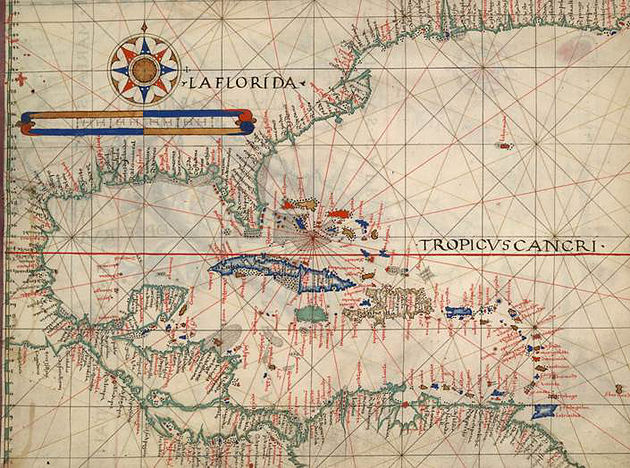
Portolan Charts
One of the most significant advancements in ancient cartography was the development of portolan charts in the 13th century.
These maps, characterized by their detailed coastlines and compass roses, were used extensively by Mediterranean sailors.
Unlike earlier maps, which were often based on speculative geography, portolan charts were created using actual navigational data, making them highly accurate and reliable for their time.
Mysteries and Enigmas Encoded in Ancient Maps
The Piri Reis Map
One of the most famous and enigmatic ancient maritime maps is the Piri Reis map, created in 1513 by the Ottoman admiral and cartographer Piri Reis.
This map is remarkable for its depiction of the Atlantic coastlines of Europe, Africa, and South America with astonishing accuracy.
What makes the Piri Reis map particularly intriguing is its inclusion of Antarctica, which was not officially discovered until 1820. The map suggests that ancient civilizations might have had knowledge of the continent long before modern explorers.
The Vinland Map
The Vinland Map, purportedly dating back to the 15th century, is another controversial artifact that has sparked debate among historians and cartographers.
The map depicts a portion of North America labeled "Vinland," which corresponds to the Viking settlement in Newfoundland, Canada.
If authentic, the Vinland Map would provide evidence that Norse explorers reached North America long before Columbus. However, the map's authenticity has been the subject of heated debate, with some experts claiming it is a modern forgery.
Sea Monsters and Mythical Lands
Ancient maritime maps are often adorned with illustrations of sea monsters, mythical islands, and fantastical creatures.
These depictions were not merely decorative; they reflected the fears, beliefs, and imaginations of the mapmakers and their contemporaries.
Sea monsters like the Kraken, mermaids, and serpents were believed to inhabit the unexplored depths of the ocean, posing dangers to sailors.
Mythical lands such as Atlantis, Hy-Brasil, and Thule also appear on these maps, hinting at lost civilizations and uncharted territories waiting to be discovered.
Scientific Analysis and Modern Interpretations
Advances in Cartography
Modern technology has allowed scientists and historians to analyze ancient maritime maps with greater precision.
Techniques such as radiocarbon dating, digital imaging, and geographic information systems (GIS) have provided new insights into the accuracy and origins of these maps.
For instance, studies of the Piri Reis map using GIS have confirmed its surprising accuracy in depicting certain coastlines, suggesting that it may have been based on even older source maps.
Debunking Myths and Legends
While some ancient maps have proven to be remarkably accurate, others have been debunked as fanciful creations or outright forgeries.
For example, the Vinland Map has been subjected to extensive testing, including analysis of the ink used, which revealed modern chemical components, casting doubt on its authenticity.
Similarly, many of the sea monsters and mythical lands depicted on ancient maps have been interpreted as symbolic representations of the unknown rather than literal depictions.
Rediscovering Lost Knowledge
Despite the skepticism surrounding some ancient maps, they continue to captivate researchers and enthusiasts.
The possibility that these maps encode lost knowledge from advanced ancient civilizations remains a tantalizing prospect. The Piri Reis map, for instance, has inspired theories about ancient seafaring cultures with advanced geographic understanding.
While definitive proof remains elusive, the study of these maps encourages a re-examination of human history and the capabilities of early civilizations.
The Legacy and Impact of Ancient Maritime Maps
Cultural and Artistic Influence
Ancient maritime maps are not only valuable historical documents but also cultural artifacts that reflect the artistry and worldview of their creators.
The intricate illustrations, calligraphy, and embellishments found on these maps have inspired generations of artists, writers, and historians.
They serve as windows into the past, offering glimpses of how people once perceived the world and its mysteries.
Navigational and Scientific Contributions
The legacy of ancient maritime maps extends beyond their historical and cultural significance. They laid the foundation for modern cartography and navigation, contributing to the development of more accurate and reliable maps.
The techniques and knowledge accumulated by early mapmakers paved the way for future explorations and discoveries, ultimately shaping our understanding of the world's geography.
Ongoing Research and Exploration
The study of ancient maritime maps is an ongoing field of research that continues to yield new discoveries and insights.
Historians, cartographers, and archaeologists collaborate to decipher these maps, uncovering forgotten histories and challenging established narratives.
As technology advances, so too does our ability to explore and interpret these fascinating documents, ensuring that their mysteries and contributions are continually re-evaluated and appreciated.
Conclusion
Ancient maritime maps are remarkable relics that offer a unique window into the past. They reveal the courage and curiosity of early explorers, the artistic talents of mapmakers, and the enduring mysteries of the ocean.
While some maps may hold clues to lost knowledge and undiscovered lands, others serve as reminders of the human propensity for imagination and myth-making.
Whether as practical tools for navigation or as captivating works of art, these maps continue to inspire wonder and exploration. As we delve deeper into their history and significance, we may yet uncover new keys to the enduring mysteries of the world's oceans.
Sources
- Smithsonian Magazine - The Piri Reis Map
- National Geographic - The Vinland Map
- British Library - Portolan Charts
- Scientific American - Ancient Maps
- BBC - Sea Monsters on Medieval Maps
- National Oceanic and Atmospheric Administration - History of Cartography
- University of Chicago - The Babylonian World Map
- Library of Congress - Ptolemy's Maps
- Ancient Origins - The Mystery of Thule
- Nature - Radiocarbon Dating of Ancient Maps